Sunday, August 1, 2010.
My friend Neal and I attempted a southbound Presidential Traverse (aka "the Presi") in New Hampshire. The Presi is a hike that, when all said and done, includes: 24 miles of mountainous hiking over and across 11 summits with 9,000+ feet of elevation gain. The general expectation is to take around 16+/- hours. The Presidentials are a series of mountains in the White Mountain National Forest in New Hampshire. Here's the list of the peaks in the attempt:
Madison, Adams, Jefferson, Clay, Washington, Monroe, Franklin, Eisenhower, Pierce, Jackson (not summited), Webster (not summited)
Our intention was to complete the full Presi traverse, but instead we made a decision after Pierce (actually at the Mizpah Spring Hut) to cut the hike short and descend via a shorter route skipping Jackson and Webster. Some regard the route we completed as the 'minimal presi traverse'.
Here's the trail report:
WEATHER
Prior to this hike all forecasts seemed very favorable, and thankfully that held up - the day was near perfect weather-wise: bright, sunny, dry and cool (55F - 60F). I was very grateful for this, given that weather conditions through the range can vary greatly making things very difficult, and my prior three hikes in NH had all been in the rain, making for wet, slippery and muddy trail conditions.
NUTRITION
My nutrition strategy was to eat a combination of peanut butter & jelly sandwiches, power bars and salted mixed nuts. For hydration I started out with Gatorade and later on switched to water.
GEAR
I wore hiking pants, a white coolmax t-shirt, hat, SmartWool socks, and my Asics Gel Trabuco Trail Running shoes. In addition I carried an REI Flash 30 backpack with my camel back hydration bladder and some extra equipment/warm clothes for safety. I also brought along my latest tech gadget, a Timex GPS watch to track the route.
LOGISTICS
A point-to-point traverse hike like this means we'd be finishing miles away from where we started, and thus needed to spot a second car at the end of the trail for transportation. So we drove up to NH the day before, rented a car locally, then spotted that car at the end of the trail for when we finished. From there we drove up to within a few miles of the starting trailhead, grabbed a carbohydrate- and protein-rich dinner, spent the night nearby and started out the next morning at 5am.
THE HIKE
APPALACHIA TRAILHEAD [Rt. 2, Gorham, NH]
This was the starting point. A simple parking lot abutting the woods. Got there in the dark, though light was starting to break so we didn't need our headlamps when we stepped foot on the trail at 5:20am. Starting temp was 55F. Since the hike is so long, it was important to start early in the day; though we started a bit later than recommended for this hike, we figured we'd make up time along the way. Early on saw a couple little frogs along the trail, not much other animal life encountered the rest of the day.


 MADISON SPRING HUT
Our first main stop during the day. There were actually three huts along the route. These are small cabin like structures nestled up in the mountains where hikers can find a bunk bed and warm meal, or for us a place to re-fill our water bottles or to use the restroom if necessary. We arrived at Madison Hut in the middle of breakfast for those who had stayed there the night before, and somewhat comically, the folks working at the hut were putting on some breakfast theater for their guests. As much as I could tell the sketch they acted out was a cross between the Wizard of Oz and Indiana Jones (starring theatrical collegiate-types playing a whip-cracking Indiana Jones and his father Sean Connery, faked accent and all) - a good laughing start to the day.
MADISON
After a relatively short hike up from Madison Spring Hut, we hit the peak of Mount Madison. It took a total of just 2:35 (2 hours 35 minutes) to hit the peak. I took time to look around and soak up the wonderful 360 degree views. At this point, the body was feeling fine, and I was ready to continue onwards after a few minutes stopped at the peak with Mount Washington looming in the distance.
MADISON SPRING HUT
The route we took brought us right back down the same path we went up from Madison Spring Hut, and after a quick stop (the second time), strode along on our way to Adams.
ADAMS
About 1:20 later, we hit the peak of Adams. After a quick stop and picture, we started onwards. But oops, I noted the wrong trail on our route sheet. Thankfully Neal figured it out quickly and our detour was limited to only 5 minutes.
THUNDERSTORM JUNCTION
It goes without saying that the terrain in a state nicknamed "the granite state" is a bit rocky. Coming down further from the path from Adams, we passed by Thunderstorm Junction, notable as an intersection of trails and for a gigantic cairn.
JEFFERSON
Took us a bit longer than expected to get to Jefferson. About 1:46 later we hit the summit, which was about 60F, took a quick snap (still looking and feeling good) and quickly turned down towards Clay.
CLAY
One hour later we hit the summit of Clay where it was a balmy 62F. Throughout the morning we had been catching glimpses of Mount Washington, and we were finally about to face it head on. At this point, 6:40 into the day, it's safe to say that we were both getting a bit tired, and our pace slowed considerably. In terms of preparation, I hadn't hiked in 5 weeks and Neal hadn't hiked in 8 weeks, so despite our generally good fitness, we could have done a bit more training leading up to this hike.
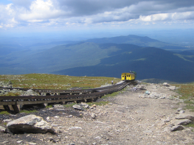
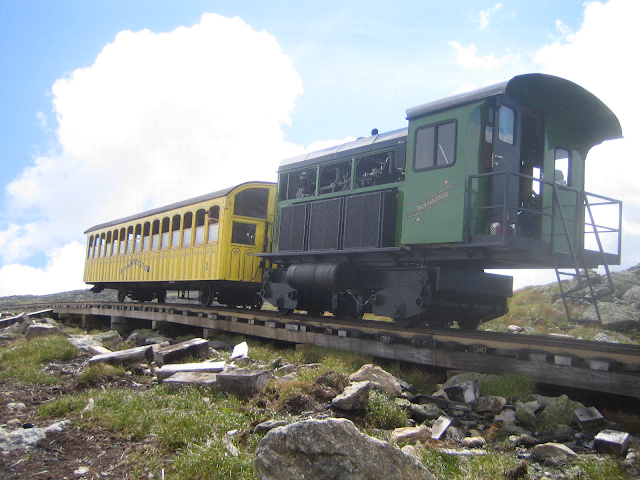
WASHINGTON
The path up followed alongside the Cog Rail train tracks that others can take to get to the summit. The trail footing was actually very good, though definitely marked by charred coal like rocks. Half-way up we got passed by two of the cog rail passenger trains.

As we hit the summit, 7:40 into the hike, there were people everywhere. A stark contrast to the earlier peaks that were primarily marked with a serene quietness, Mount Washington was a bit like a zoo. The first order of business was to get the token picture with the summit sign, for which we waited in a short line and then jumped right to the sign. After re-filling our bottles with water, we sat in the cafe, ate and relaxed a bit. I took the chance to re-tape my left ankle which I had sprained only two weeks earlier. Needless to say we were feeling the effects of the hike thus far; quads, calves and feet were absorbing the brunt of the effort. And after 30 minutes (a bit longer than anticipated), we set foot back on the trail headed down Washington.
Not far from the summit, at an open clearing there were a couple folks flying large parachute style kites, neat.
LAKES OF THE CLOUDS HUT
After descending from Mount Washington, we hit a long stretch of ridge-line on our way to the Lakes of the Clouds Hut. There was a lot of foot traffic on this path, but it wasn't too hard to get around anyone coming or going. I didn't go into hut, but the approach was very nice, nestled in the vast mountainscape, with the clouds reflecting off the clear, crisp, mountain lake water - the hut was aptly named.
MONROE and FRANKLIN
Within the next hour we hit the summits of both Monroe and Franklin. At this point, every step was pretty painful for me, but kept it going one step at a time.
EISENHOWER
The trek to Eisenhower seemed like an eternity, and wow, each next peak just seemed even more colossal than the last. This wasn't actually true, but certainly seemed that way given how thrashed I felt.
PIERCE
Along the hike we encountered so many different people, all doing different hikes and having various experiences throughout the day. On the way down from Eisenhower and over to Pierce, we took a short break and as we stopped to rest, two ladies literally came prancing down the trail with great spirit and energy. They stopped alongside us to chat, and we found out that they started from the same trailhead as we did this morning, but were skipping the peaks - a bit less elevation gain than us, but still an incredibly long day hike and they seemed barely to break a sweat. Inspired, we tried to put on some smiles by the next summit.
MIZPAH SPRING HUT
Until we arrived at the Mizpah Spring Hut, I was holding onto hopes of finishing the full traverse. But after some brief discussion, it was agreed to descend via the Mizpah Cut-Off and Crawford Path (still not a particularly easy descent) cutting off the last two peaks of Jackson and Webster.
NH-302 (CRAWFORD PATH, AMC HIGHLAND CENTER)
Given the time of day and our condition at that point, I was totally fine with this decision. If we had kept on going, we most certainly would have had to finish in the dark with our headlamps on, and given my weariness, that may have been risking things a bit too much. So putting safety first, we came down from the mountains after another 1:20, arriving at the southern trailhead (NH-302 at the start of Crawford Path near the AMC Highland Center) at exactly 7:00pm, a total hike time of 13:40.
POST HIKE
After the hike I right away changed into dry clothes, stretched a little and scarfed down some quick protein as we made our way back to the starting trailhead to pick up the other car. Got back home to Boston before midnight, not bad after such a long day. A bit of soreness and two blisters lasted for a couple days after the hike, but slowly faded away.
Am really happy about the day - it was a great hike with a great friend. Am thankful that we were able to go the distance and time we did, got to see some spectacular views, and came off the mountains unscathed.
FINAL STATS AND GPS PLOTS
9 peaks
21.66 miles
13 hours 40 minutes
8,500 feet of elevation gain (13,802 feet according to the GPS)


